Characterization of the river basin Canoabo in the Carabobo State, Venezuela. II. Grounds and lands
Abstract
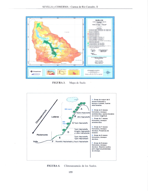
The objective of this paper is to present a soil characterization and a land capability that supports better agroecological planning. For this purpose a characterization of the main soil-forming factors was carried out; this included a phtointerpretation of satellite imagery, a digital elevation model, a map of vegetation and land cover, and a map of parent materials. All these digitized layers were superimposed with a Geographical Information System (GIS) to produce a preliminary soil cartographic map. Fifty field sites were analyzed including its geomorphology, land use, erosion, drainage, soil profile, taxonomy, and land capability classification. Results showed a clear climosequence expressed by a Humic Haplustult in the more humid higher mountains, Haplustalf dominating the intermediate side slopes, somewhat more leached in the higher slopes and shallower and eroded in the lower ones, and finally, Haplustepts in the lower valleys derived from more recent alluvial materials. Land Capability showed that in the valleys dominated the classes I to IV, while the side slopes were mostly Class VI, and the high mountains had classes VII and VIII. The slope was the dominant factor to differentiate classes. The mainland use conflict is overutilization of steep slopes by cattle and citrus, as well as underutilization of flat slopes en the valley. Consequently, the main recommendation is to intensify land use in the valleys and to develop more sustainable land use systems in the slopes, including soil conservation practices
Downloads
References
• COMERMA, J. y L. ARIAS. 1971. Un sistema para evaluar la capacidad de uso agropecuario de los terrenos de Venezuela. In: Primer seminario sobre clasificaciones interpretativas de suelos con fines agropecuarios. Maracay, Sociedad Venezolana de la Ciencia del Suelo. p. 1-19.
• COMERMA, J. 2004. Capacidad de uso agrícola de las tierras en Venezuela. Informe técnico, PEQUIVEN, Morón. 34 p.
• EDELCA. 2003d. Estudio Plan Maestro de la Cuenca del río Caroní. Conflictos de Usos de las Tierras de la Cuenca del río Caroní. Caracas Venezuela. 31 p.
• ELIZALDE, G. 1983. Ensayo de clasificación sistemática de categorías de paisajes. Informe técnico. Instituto de Edafología. Facultad de Agronomía, UCV, Maracay, 43 p.
• ELIZALDE, G., J. VILORIA y J. OCHOA. 2006. Caracterización Geomorfológica de la Cuenca del río Canoabo, en el estado Carabobo. Informe técnico. UCV, FAGRO, Maracay.
• ESRI, 2005. ArcGis 9.0. Redland, California, USA. https://bit.ly/31mw4UG
• GILABERT, J.; I. LÓPEZ y R. PÉREZ. 1990a. Manual de Métodos y Procedimientos de Referencia (análisis de suelos para diagnóstico de fertilidad) FONAIAP- CENIAP. Maracay. 164 p. (Serie D N° 26).
• GILABERT, J. y L. NIEVES. 1990b. Manual de Métodos Analíticos para Caracterizar Perfiles de Suelos. FONAIAP-CENIAP. Maracay. 164 p. (Serie D, N° 26).
• LORES, C. 2006. Caracterización de la Cobertura Vegetal y el Uso Actual de la Cuenca del río Canoabo. Informe técnico. PEQUIVEN, Morón. 40 p.
• MOGOLLON, L. y J. COMERMA. 1994. Suelos de Venezuela. PDVSA PALMAVEN, Editorial EXLIBRIS. 21 p.
• PALMAVEN. 1999. Proyecto "Desarrollo Regional Occidente. Capítulo Carabobo (DRO-Carabobo)". Guacara. Estado Carabobo.
• SEVILLA, V., J. COMERMA y O. SILVA. 2008a.Caracterización de la cuenca del río Canoabo. I Análisis Climático y de Producción de agua. Agronomía Trop. 59(1):33-44.
• URBANI, F y J. A. RODRIGUEZ. 2003. Atlas geológico de la cordillera de la costa, Venezuela. Coedición FUNVISIS y UCV, iii + 146 p. (146 mapas a escala1:25.000).
• USDA. 2003. Keys to Soil Taxonomy. Ninth Edition. Disponible en: https://bit.ly/3gtXKx1


