Áreas ambientalmente sensibles a la desertificación en la microcuenca Callecitas, estado Guárico
Resumo
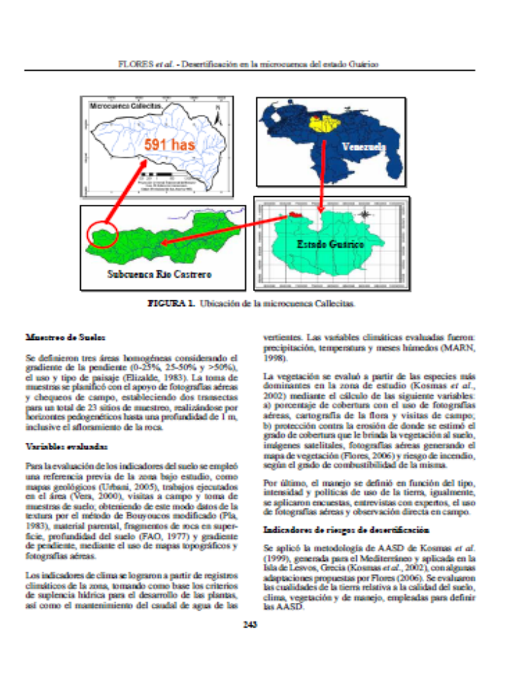
La desertificación es la consecuencia de un conjunto de procesos activos en ambientes áridos, semiáridos y subhúmedos secos. Se evaluó la microcuenca Callecitas, importante tributario del río El Castrero que aporta agua a San Juan de los Morros capital del estado Guárico y al embalse de Camatagua. Se definieron las áreas ambientalmente sensibles a la desertificación (AASD), agrupando los indicadores en cuatro cualidades que definen la calidad del suelo, clima, vegetación y manejo. El enfoque empleado se apoya en características que pueden ser tomadas fácilmente en campo. Se calificaron los atributos: textura de suelo, material parental, fragmentos de rocas en superficie, gradiente de la pendiente, profundidad del suelo, distribución de las precipitaciones, riesgo de incendio de la vegetación, protección de la flora contra la erosión, resistencia de la vegetación a la sequía, cobertura de la planta, intensidad y uso de la tierra y la aplicación de políticas para su protección. Se utilizó un sistema de información geográfico para generar el mapa final de las AASD, así como, los mapas de los atributos mencionados. Los resultados muestran que el 69,2% del área presenta niveles críticos de sensibilidad a la desertificación, mientras que el 30,3% es frágil. No se evidenciaron zonas libres de riesgo, siendo el sobrepastoreo, las altas pendientes, una vegetación natural muy pobre y los cultivos anuales intensivos, las causas que promueven la degradación de la tierra.
Downloads
Referências
• Flores, B. 2006. Impacto de los sistemas de producción agrícola sobre la calidad de suelo para la producción sostenible de agua y su relación con los riesgos de desertificación en la subcuenca “Callecitas” del río “El Castrero”, estado Guárico. Tesis de M. Sc. Universidad Central de Venezuela. Maracay. 144 p.
• Holtz, U. 2003. La Convención de las Naciones Unidas de lucha contra la desertificación y su dimensión política (en línea). 14 p. Disponible en: https://bit.ly/2Uq3lvz Consultado el 6 de mayo de 2009.
• Kirkby, M. and C. Kosmas. 1999. Introduction (en línea). In: The medalus project Mediterranean desertification and land use. Manual on key indicators of desertification and mapping Environmentally Sensitive Areas to desertification. 9-10 pp. Disponible en: https://bit.ly/2w0oq6E Consultado el 4 de diciembre de 2007.
• Kosmas, C., A. Ferrara, H. Briassouli and I. Imeson. 1999a. Methodology for mapping ESAs to desertification (en línea). In: The medalus project Mediterranean desertification and land use. Manual on key indicators of desertification and mapping Environmentally Sensitive Areas to desertification. 31-47 pp. Disponible en: https://bit.ly/2QVstbs Consultado el 4 de diciembre de 2007.
• Kosmas, C., S. Gerontiditis, V. Detsis, T. Zafirius and M. Marathianou. 1999b. Aplication proposed of the methodology for defining ESAs (The lesvos island, Greece) (en línea). In: The medalus project Mediterranean desertification and land use. Manual on key indicators of desertification and mapping Environmentally Sensitive Areas to desertification. 66-72 pp. Disponible en: https://bit.ly/2xx6jFT. Consultado el 4 de diciembre de 2007.
• Kosmas, C., S. Gerontidis, M. Tsara, M. Marantianou and N. Yassoglou. 2002. Defining environmentally sensitive areas to desertification: An application to the Island of Lesvos. Proceedings of the Third International Congress Man and Soil at the Third Millennium. Geoforma Ed. Logroño, España, 2:1 233 - 1 253.
• Ministerio del Ambiente y de los Recursos Naturales Renovables (MARNR). 1998. Zonificación agroclimática del estado Cojedes y del estado Guárico. Dirección General Sectorial de Información e Investigación del Ambiente. Dirección de Hidrología y Meteorología. Caracas. Vol. 1B. 140 p.
• Organización de las Naciones Unidas Para la Agricultura y la Alimentación (FAO). 1977. Guía para la descripción de perfiles de suelos. (2ª Ed.). Servicio de fomento y conservación de recursos de suelos. Dirección de Fomento de Tierras y Aguas. Roma. 70 p.
• Petróleos de Venezuela S.A. (PDVSA) - Instituto de Tecnología Venezolana para el Petróleo (INTEVEP). 2000. Código Estratigráfico de las cuentas petroleras de Venezuela. (En línea) Editado por el Comité Interfilial de Estratigrafía y Nomenclatura (CIEN). Disponible en: https://bit.ly/2WTptQD
• Pla, I. 1983. Metodología para la caracterización física con fines de diagnóstico de problemas de manejo y conservación de suelos en condiciones tropicales. Rev. Facultad de Agronomía. Universidad Central de Venezuela. Alcance Nº 32. 94 p.
• Pla, I. 2005. Hydrological approach for assessing desertification processes in the Mediterranean region. In: Desertification in the Mediterranean Region. A Security Issue. Springer. Heidelberg. Alemania. 579-600 pp.
• Programa de las Naciones Unidas para el Medio Ambiente (PNUMA). 1999. ¿Qué es la desertificación? (en línea). Oficina Regional para América Latina y El Caribe. 9 p. Disponible en: https://bit.ly/39xv8yQ Consultado el 4 de diciembre de 2007.
• Rubio, J., and E. Brochet. 1998. Desertification indicators as a diagnosis criteria for risk assessment in Europe. Journal of Arid Environments. 39(2):113-120.
• Santibáñez, F. y J. Pérez. 1997. Metodología unificada para la evaluación y monitoreo de la desertificación en América Latina. Indicadores de desertificación. FAO, PNUMA. Santiago, Chile. 189 p.
• United Nations Convention to Combat Desertification (UNCCD). 1994. Intergovernmental negotiating committee for the elaboration of an international convention to combat desertification in those countries experiencing serious drought and or desertification, particularly in Africa. United Nations, New York, USA.
• Urbani, F. 2005. Nomenclatura de las unidades de rocas ígneas y Metamórficas de la Cordillera de la Costa, Venezuela. Boletín técnico IMME. 43(2):1-10
• Vera, E. 2000. Análisis de sensibilidad ambiental como instrumento de ordenamiento territorial de la microcuenca El Castrero, estado Guárico. Tesis de M.Sc. Universidad Central de Venezuela, Maracay. 92 p.


